Pakistan indigenous earth observation satellite marks new space milestone
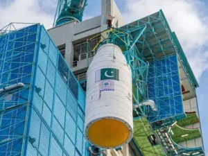
The successful launch of Pakistan indigenous earth observation satellite EO 2 signals a major step forward in the country’s growing space ambitions. Developed by SUPARCO, the satellite was launched from Yangjiang Seashore Launch Centre with support from China. The mission reflects Pakistan’s steady progress in building local technological capacity.
EO 2 is designed to deliver high resolution imagery that supports urban planning, climate monitoring, disaster response, and natural resource management. Leaders including Prime Minister Shehbaz Sharif praised the achievement, calling it an important moment for national development and scientific advancement.
Background and technical significance of Pakistan indigenous earth observation satellite
The Pakistan indigenous earth observation satellite builds on earlier space missions and reflects the country’s expanding expertise in satellite engineering. EO 2 improves data coverage and precision, allowing authorities to monitor environmental changes, track infrastructure growth, and manage agricultural planning more effectively.
The project highlights how local scientists and engineers are moving toward self reliance in advanced technology. By producing consistent and reliable data, EO 2 strengthens Pakistan’s capacity to make informed policy decisions based on accurate observation and analysis.

Analysis of Pakistan indigenous earth observation satellite and national development impact
The Pakistan indigenous earth observation satellite is expected to deliver practical benefits across multiple sectors. Reliable imagery will help authorities respond faster to floods, earthquakes, and climate related emergencies. Urban planners can use updated data to guide expansion while protecting the environment.
In agriculture, satellite monitoring may improve crop forecasting and water management strategies. The launch also signals that Pakistan is serious about building a competitive space programme, which can encourage research partnerships and inspire young scientists to pursue careers in science and technology.

Strategic and international cooperation in Pakistan indigenous earth observation satellite programme
International cooperation played an important role in the Pakistan indigenous earth observation satellite project. Collaboration with China reflects the broader scientific and technological ties between the two countries. Such partnerships allow Pakistan to gain technical exposure while developing local capabilities.
At the same time, the project shows a gradual shift toward more domestically engineered systems. Balancing foreign cooperation with local innovation will remain essential for sustaining progress in future missions.

Recommendations to maximise benefits from Pakistan indigenous earth observation satellite
To get the most value from the Pakistan indigenous earth observation satellite, policymakers should integrate satellite data into public sector planning and research institutions. Expanding academic partnerships and encouraging private sector innovation could help translate space technology into real economic growth.
Training programmes for data analysts and urban planners would ensure that satellite information is used effectively. Strong coordination between government agencies will also help turn data into practical policy outcomes.

Way forward for Pakistan indigenous earth observation satellite and future space ambitions
The success of the Pakistan indigenous earth observation satellite offers a clear path for future missions. Continued investment in research, technology education, and international collaboration can strengthen the country’s position in the global space community.
Expanding satellite fleets, improving local manufacturing capacity, and promoting science education among youth will help sustain momentum. With consistent planning and support, Pakistan’s space programme can play a growing role in national development and regional technological advancement.